Image metadata & AI inspector

Find out whether an image was AI-generated, edited with tools like Photoshop, or still carries its original capture details. PNGchunk reads EXIF, IPTC, XMP, PNG chunks and generation metadata so you can see prompts, software, camera make and model, author or copyright credits, and other embedded fields in one place.

Upload a file or paste an image URL to inspect GPS location on a map when coordinates are present, review file and pixel details, and run a layered check for AI and edit signals—including Stable Diffusion-style PNG info when available. No local Stable Diffusion server required.

Upload

  • PNG, JPEG, WebP, GIF, TIFF, HEIC, AVIF, RAW
  • Filesize max 15MB
  • 1 file at a time

Drag and drop a file here or click

Drag and drop or click to replace

Load image from URL

Result

Address

Nearby places

Loading nearby places can take some time. Places are ordered by straight-line distance from the photo.

    © OpenStreetMap contributors · Address via Nominatim · Nearby places via Photon

    What PNGchunk shows in your images

    Upload a photo or paste an image URL and the inspector surfaces an AI and edit verdict, AI generation settings when they are embedded in the file, structured metadata, and—when GPS is present—a map with address details and nearby places. Use the overview below, then read each section for what every field means.

    AI image inspector: generated, real, or edited?

    The AI inspector checks embedded generation data, provenance cues, and camera capture clues to help answer whether an image looks AI-generated. It also flags when software history suggests the file was likely edited—for example in Adobe Photoshop or similar tools.

    • AI verdict — AI-generated, likely AI, likely a real photograph, or inconclusive when metadata is thin.
    • Edit verdict — Highlights likely editing when creator tools, history, or software tags point to post-processing.
    • Evidence summary — Short notes on why the verdict was chosen (prompts, model tags, camera EXIF, signed provenance, and more).
    • Works without a local SD server — Reads Stable Diffusion-style PNG info and other embedded generation fields when they travel with the file.
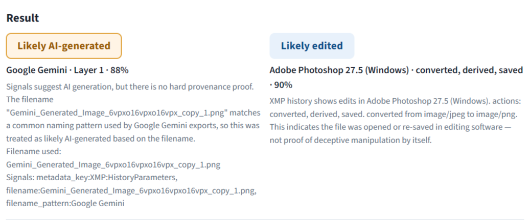
    AI and edit verdicts appear at the top of the result panel after upload.

    AI image generation information: tool, prompt & model

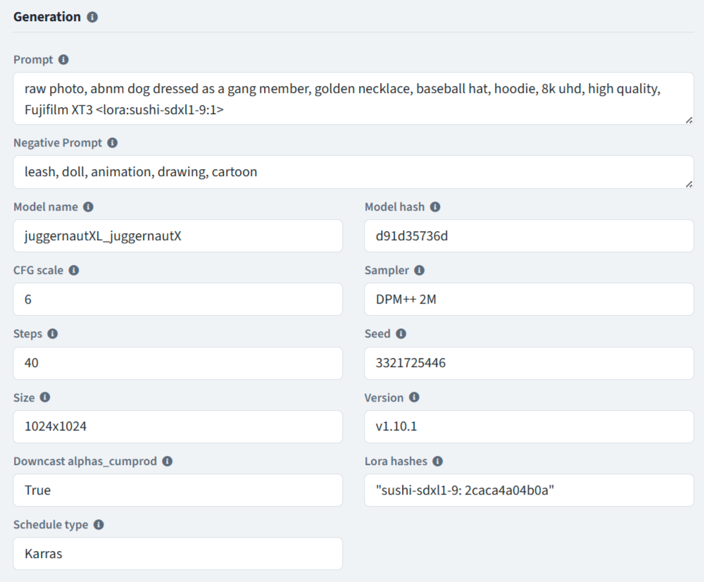
    When an AI tool embeds generation metadata—common with Stable Diffusion, Automatic1111, ComfyUI, InvokeAI, and many hosted generators—PNGchunk extracts those fields into a dedicated Generation group so you can see how the image was made, not only that it looks synthetic.

    • Software / tool — The generator or app named in the file (for example Automatic1111, ComfyUI, or an AI platform tag).
    • Prompt & negative prompt — The text instructions used to create the image, and what the model was told to avoid.
    • Model — Checkpoint or model name, hash, and related identifiers when present.
    • Sampler, steps & CFG — Sampling method, step count, and guidance scale from popular SD workflows.
    • Seed & size — Random seed for reproducibility and the generation width × height.
    • Workflows & extras — ComfyUI prompt graphs, VAE, refiner, hires fix, and other embedded settings when the file includes them.
    Generation fields surface the prompt, model, and tool settings embedded in AI images.

    Image metadata viewer: EXIF, IPTC, XMP & PNG chunks

    Beyond verdicts and generation settings, PNGchunk organizes the metadata embedded in PNG, JPEG, WebP, GIF, TIFF, HEIC, AVIF, and many RAW files. Fields are grouped so you can scan highlights first, then open the full RAW dump for every tag ExifTool reports.

    • Image source — Camera, stock library, editor, or AI generator clues.
    • Camera — Make, model, lens, exposure, ISO, aperture, shutter, and capture time from EXIF.
    • Image details — File type, pixel dimensions, color space, and related technical properties.
    • Copyright & credits — Author, credit, rights, captions, and document identity from IPTC/XMP/EXIF.
    • Location tags — GPS and place names when written into the file (separate from the interactive map below).
    • RAW panel — Complete technical metadata for copy, audit, or debugging.
    Metadata is grouped for scanning, with info tips on each field and a full RAW view.

    Photo location on a map & nearby points of interest

    When a photograph still contains GPS coordinates, PNGchunk plots the capture point on an interactive map. From those coordinates it can resolve a human-readable address and, on request, load nearby places ordered by straight-line distance from the photo.

    • Map pin — Latitude and longitude from EXIF/GPS tags visualized with OpenStreetMap tiles.
    • Address — City, region, country, and related place labels from reverse geocoding.
    • Nearby places — Points of interest around the shot so you can understand the area context.
    • Privacy reminder — GPS can reveal where a photo was taken; strip location before sharing if that matters.
    GPS-backed photos get a map, address enrichment, and optional nearby places.